I have fallen behind in the GoodReads Reading challenge. I read nine books in May before and on the first few days of our recent cruise.
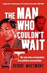
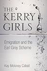
Of my May reads I enjoyed and learnt so much about recent Sydney history in The Man who couldn't wait: the true story of Australia's first political assassination. While I found the content in The Kerry Girls most interesting I found it a drag to read, perhaps it needed more editing.
Towards the end of the cruise I fell ill with pneumonia and, on disembarkation, was admitted to hospital in Cape Town, South Africa. While I had a lot of potential reading time on my hands conditions there prevented me from using it to read. One arm was hooked up to a drip, the other arm was tied by leads to a beeping monitor and I was masked in regular sessions on a nebuliser so I couldn't easily read a real book or an eBook on my phone. I could have tried audio books but I couldn't be bothered.
After getting out of hospital and unhooked from gadgets I read four books in June. I found the true crime story London Falling unputdownable and A Land Rover named Lucy a most readable and humourous travel tale.


